
Partner
// Landes Attractiveness Agency, aka Landes Attractivité.
// The agency coordinates with the county’s 17 tourist offices to promote and enhance the region’s tourism offering. Its new statutes (2022) affirm its strong role in data management, including both the Tourism Information System (SIT) and OpenStreetMap (OSM).
// The Landes in 2021: 9,243 km², 451,000 tourist beds, 19.5 million overnight stays in a region that is as rural as it is coastal. An extensive range of hiking trails (230 official routes), cycle paths and tracks. For hikers, the department is crossed by the Littoral and Turonensis pilgrimage routes; for cyclists, by the Scandibérique and Vélodysée routes.
The project
The Agency’s project, launched in 2020 and implemented from March 2021, is based on pioneering/exemplary projects carried out by Teritorio in the region (Seignanx, Pays ALO, Saint-Paul-les-Dax). It aims to maintain a sustained level of contribution to OSM across the Landes region by tourist offices and their local partners (local authorities, associations, public service operators) and to deploy a web mapping application.
All of the region’s tourist offices (17) are involved. In conjunction with the Regional Tourism Committee (CRTNA), the project seeks to complement SIT data (accommodation, restaurants, leisure activities, etc.) with OSM data (facilities, mobility, health, small natural or cultural heritage sites). The decision has been made to source local shops (butchers, bakeries, grocery stores, etc.) via OSM.
A documentary that tells the story of the work
There is also a subtitled version of this film.
The process – since March 2021
- Initial strategic project:
- organization of a project workshop for the management team;
- drafting a strategic memo for regional development (why, how);
- definition of a plan for organized contributions to OSM (what/who/when);
- definition and implementation of a continuity plan.
- Training and support for the regional tourism committee and 17 tourist offices.
- Establishment of a two-tier support organization.
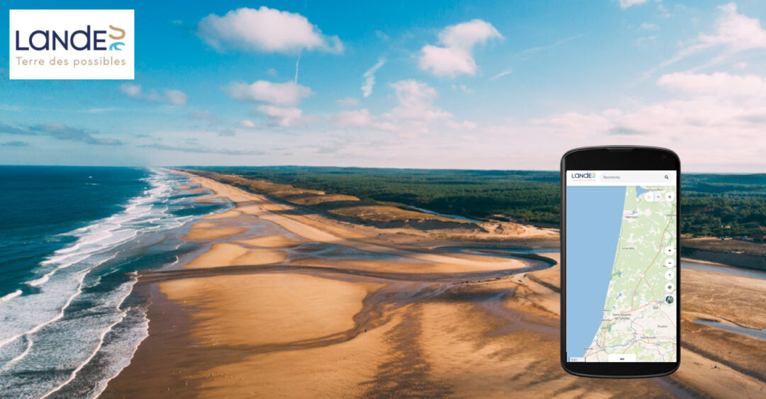
- Development and maintenance of the web app : Carte Touristique des Landes
- which provides: 15,000 points of interest (7,500 from Sirtaqui, 7,500 from OSM)
- accessible from the website www.tourismelandes.com
- Reuse of data in a map embedded specifically for the Landes Attractivités website.
Results
Successful launch of the project
Project completed in 4 months
- Training of the regional project team: intensive and technical training in OSM data management.
- Training of 65 members of staff from tourist offices with the support of MONA : 100 people reached (incidental training).
- Responsive management of the region support team (email, video conferencing).
- Release of the beta version of the application at the end of June 2021:
- Stabilization of the production version at the end of September 2021.
- Excellent group dynamics with the 17 tourism offices participating regularly throughout the project and demonstrating strong commitment in the field.
- Demonstration of the importance of the regional development council’s role in leading such a project, which requires engineering, organizational resources, and additional support (two interns were involved).
Improved quality of territorial data
- The focus on mapping and comparison with OSM data improves approximately 30% of the geolocation of regional POIs.
- Approximate positioning when entering via Google Maps (zoom factor issue).
- Positioning calculated automatically based on the address, with recalibration to the center of a street, for example, when the number cannot be found.
In June 2022, on OSM
- Over 10,000 changesets (sets of modifications in the database)
- A real impact on the quantity/quality of data in OSM
- A big thank to https://ohsome.org/apps/dashboard/
Strong impact on tourism key (various POIs)

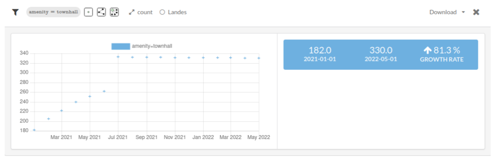
Contribution to improving data of town halls (POI included in the work plan)
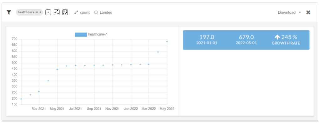
A significant impact on health data (health center, doctor, etc.)
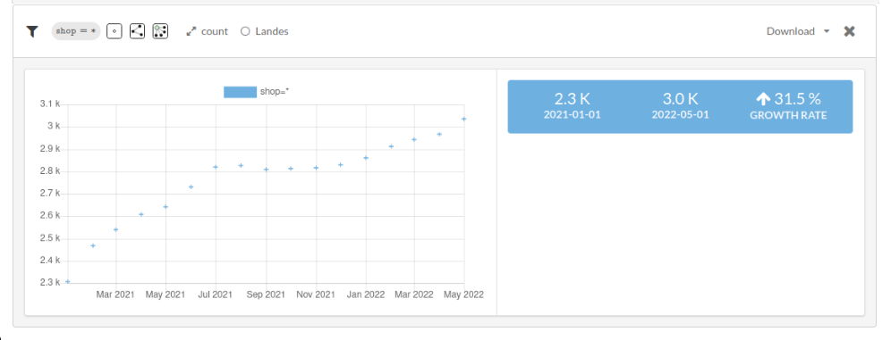
Participation in the efforts regarding commercial data
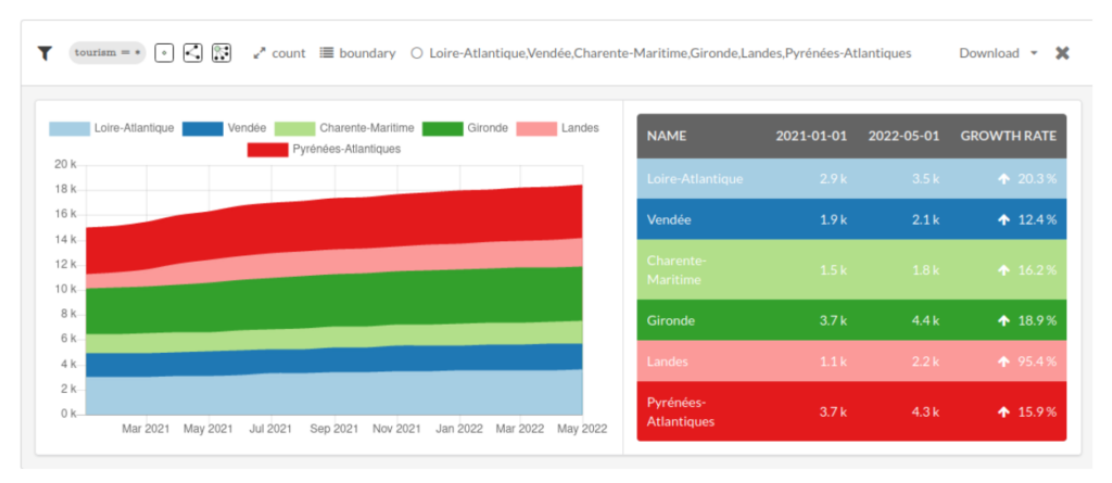
Finally, a comparison (contribution rates) across the Atlantic coast.
Years 2022 and 2023
Local momentum for OpenStreetMap projects
- Launch of 7 local web app projects with tourist offices: many other local territories are involved in updating OSM data (Grand Dax Tourist Office, Landes Altantiques Sud Tourist Office, Mimizan Tourist Office, Bica Grands Lacs Tourist Office, Pays Tarusate Tourist Office, Hossegor Tourist Office, Vallée du Kiwi Tourist Office).
- Monitoring updates in three regions committed to implementing tourism maps.
- Confirmation of the value of the Landes application by regions that are unable or unwilling to commit to a local project:
- use of bookmarks, facilitating the work of greeting visitors.
- promotion of hiking opportunities and outdoor equipment.
- Reuse of data in a map embedded specifically for the Landes Attractivités website
- Research and development for better coexistence of tourisl information system data and OSM data
Years 2024 and 2025 – the carteslandes.com project
Landes attractivité is reinforcing a project aimed at all residents (temporary visitors and permanent residents) by transforming the website: carte.tourismelandes.com into carteslandes.com.
- Provide access to datasets for “residents” (education, social, economic, health, etc.)
- Training local government officials to help update data (examples in Seignanx, Hossegor, Bisca Grands Lacs, Hossegor, and the Kiwi Valley)
The map currently highlights 18,800 points of interest: 6,200 from the Tourism Information System and 12,800 from OpenStreetMap (OSM).
Good to know
See our other project references
En savoir +